A large area of Brisbane is situated on low-lying floodplains, this combined with a number of suburban creeks increases the risk of some suburbs to flooding. The Brisbane City Council (BCC) has a number of requirements when it comes to building in these flood risk areas to ensure flood safe dwellings are constructed.
The BCC has 2 very helpful tools when it comes to identifying the flood risk to your property. You can obtain a free FloodWise Property Report which summarises the flood risk to your property. You can also view a map of Brisbane and select the flood overlay which will give you a graphical representation of the flood zones via the Brisbane City Plan 2014 Online Mapping Tool.
Flood Zones
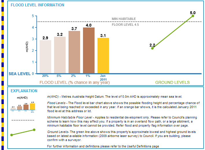
If you are in a flood zone the FloodWise Property Report will give you details on the possible flood levels and the minimum habitable floor level (MHFL) at the selected address. The MHFL is a height relative to sea level giving the minimum height a floor level must be for any new dwellings, raise & build under or extensions to houses in Brisbane.
Overland Flow Paths
There are certain properties that are flagged as being in an overland flow path. These zones are not as high risk as standard flood zones, however, surface water runs across these areas to reach waterways or flood zones. There are no stated MHFL’s on reports by the BCC for these properties. To construct in these areas an assessment by a hydraulic engineer is needed to determine an appropriate MHFL.
If you have any questions about your new home renovation, extension or raise & build under please don’t hesitate to give us a call at 1STRUCT Building and Renovation.